Moderate Snow to Impact Travel on I-80 in Southeast Wyoming Today
Those traveling on Interstate 80 in southeast Wyoming today will want to plan on slippery road conditions, as moderate snow is expected.
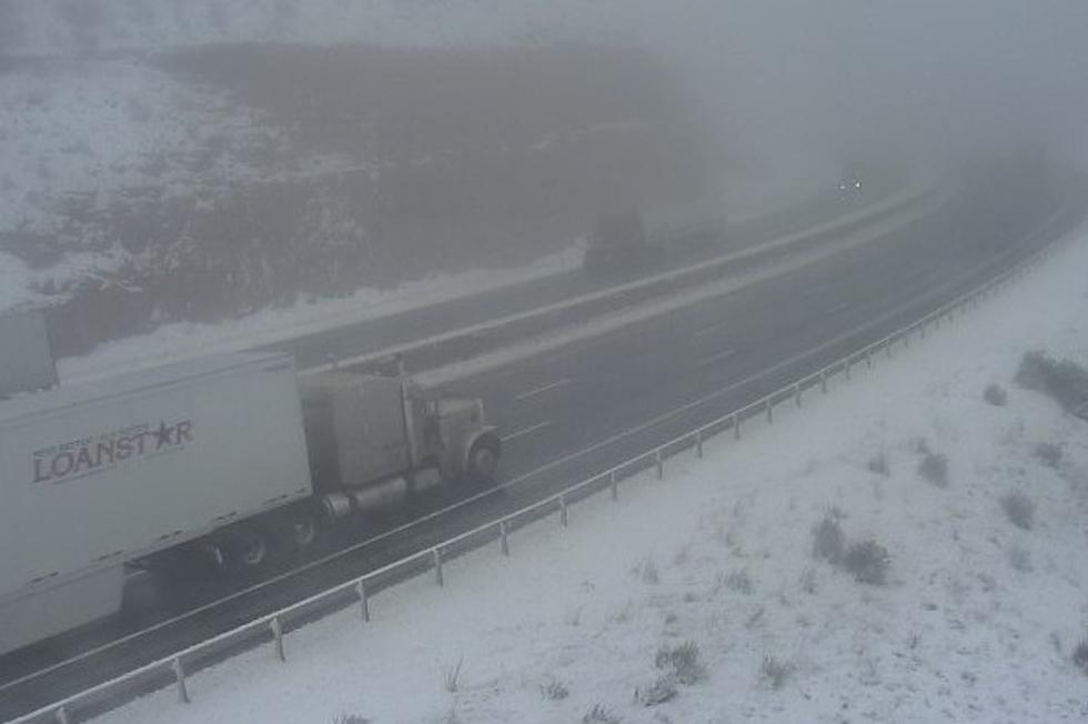
Winter Weather Advisories are in effect until 6 a.m. Saturday, which include the stretch between Elk Mountain and Arlington and the I-80 Summit.
URGENT - WINTER WEATHER MESSAGE
National Weather Service Cheyenne WY
102 AM MDT Fri Apr 14 2023

WYZ110-117-150000-
/O.EXB.KCYS.WW.Y.0025.230414T1200Z-230415T1200Z/
North Snowy Range Foothills-South Laramie Range Foothills-
Including the cities of Arlington, Elk Mountain, Whitaker,
Federal, and Horse Creek
102 AM MDT Fri Apr 14 2023

...WINTER WEATHER ADVISORY IN EFFECT FROM 6 AM THIS MORNING TO
6 AM MDT SATURDAY...

* WHAT...Snow expected. Total snow accumulations of 2 to 4
  inches.

* WHERE...North Snowy Range Foothills and South Laramie Range
  Foothills.

* WHEN...From 6 AM this morning to 6 AM MDT Saturday.

* IMPACTS...Plan on slippery road conditions. The hazardous
  conditions could impact the morning and evening commutes.

PRECAUTIONARY/PREPAREDNESS ACTIONS...

Slow down and use caution while traveling.

The latest road conditions for the state you are calling from can
be obtained by calling 5 1 1.
URGENT - WINTER WEATHER MESSAGE
National Weather Service Cheyenne WY
102 AM MDT Fri Apr 14 2023

WYZ112-114-150000-
/O.EXT.KCYS.WW.Y.0025.000000T0000Z-230415T1200Z/
Sierra Madre Range-Snowy Range-
Including the cities of Centennial and Albany
102 AM MDT Fri Apr 14 2023

...WINTER WEATHER ADVISORY NOW IN EFFECT UNTIL 6 AM MDT
SATURDAY...

* WHAT...Snow expected. Total snow accumulations of 6 to 9
  inches, mainly above 9000 feet. Winds gusting as high as 35
  mph.

* WHERE...Sierra Madre Range and Snowy Range.

* WHEN...Until 6 AM MDT Saturday.

* IMPACTS...Hikers and snow mobilers could become disoriented
  and lost due to poor visibility in snow and blowing snow.

PRECAUTIONARY/PREPAREDNESS ACTIONS...

Slow down and use caution while traveling.

The latest road conditions for the state you are calling from can
be obtained by calling 5 1 1.
URGENT - WINTER WEATHER MESSAGE
National Weather Service Cheyenne WY
102 AM MDT Fri Apr 14 2023

WYZ116-150000-
/O.EXT.KCYS.WW.Y.0025.230414T1200Z-230415T1200Z/
South Laramie Range-
Including the cities of Buford, Pumpkin Vine, and Vedauwoo
102 AM MDT Fri Apr 14 2023

...WINTER WEATHER ADVISORY NOW IN EFFECT FROM 6 AM THIS MORNING
TO 6 AM MDT SATURDAY...

* WHAT...Snow expected. Total snow accumulations of 3 to 6
  inches.

* WHERE...South Laramie Range including the Interstate 80 Summit.

* WHEN...From 6 AM this morning to 6 AM MDT Saturday.

* IMPACTS...Plan on slippery road conditions. The hazardous
  conditions could impact the morning and evening commutes.

PRECAUTIONARY/PREPAREDNESS ACTIONS...

Slow down and use caution while traveling.

The latest road conditions for the state you are calling from can
be obtained by calling 5 1 1.
"We may need to further expand the advisories to cover Saratoga, Laramie and Cheyenne later today depending on how this storm system develops," the National Weather Service in Cheyenne said.

14/230AM: Greetings! Winter Weather Advisories have been expanded in area and time this morning. The I-80 Corridor near Arlington/Elk Mountain (mile markers 290-320) and the eastern foothills of the south Laramie Range have been added to the winter weather advisories through 6AM Saturday. We may need to further expand the advisories to cover Saratoga, Laramie and Cheyenne later today depending on how this storm system develops. Given the snow is mostly going to fall during the daylight hours, accumulations on road surfaces may not be too bad. We decided to hold off on including these three areas for right now. Stay tuned!

The NWS says a cold rain is expected across the Nebraska Panhandle.
"It will be cold enough tonight to see some snow showers in the Panhandle into Saturday morning," the NWS said.
The NWS says sunny, warmer, dry weather is expected Sunday and Monday before another cold front moves into the area Tuesday, increasing chances for afternoon and evening showers and thunderstorms.

14/315AM: Howdy! Forecast for southeast Wyoming and Nebraska Panhandle calls for unsettled weather for just about everyone today and Saturday. A cold front moved through overnight, bringing colder temperatures and unsettled weather. Snow is expected across southeast Wyoming with a cold rain across the Nebraska Panhandle. It will be cold enough tonight to see some snow showers in the Panhandle into Saturday morning. For Saturday, look for slowly decreasing showers through the afternoon. Sunny skies, warmer temperatures and dry weather expected Sunday and Monday. Next cold front expected to move into the area Tuesday for increasing chances for showers and thunderstorms during the afternoon and evening.
GOAT Snowstorm in Casper - April 3-4, 2023.
Gallery Credit: Kolby Fedore, Townsquare Media
WYDOT Urges 'Don't Crowd the Plow!' After 105 Plows Hit in 5 Years
Gallery Credit: Joy Greenwald
More From K2 Radio