New Map Depicts Wyoming’s Precambrian Basement
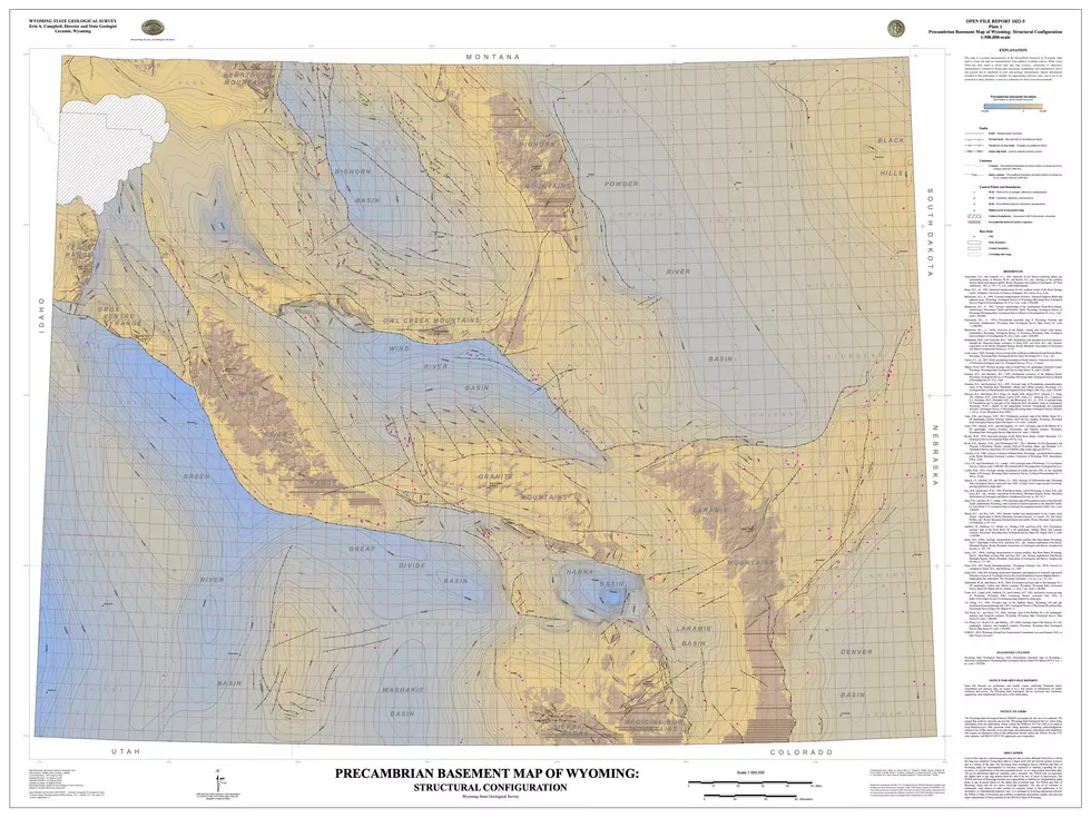
The Wyoming State Geological Survey (WSGS) published a new map depicting the structural configuration of the Precambrian basement in Wyoming. "Basement" refers to very old crystalline rocks that comprise the core of most mountain ranges and define the structure of the adjacent basins.
In Wyoming, basement rocks are Precambrian-age (more than 541 million years old) igneous and metamorphic rocks. Within the basins, and above the Precambrian basement, are thousands of feet of much younger sedimentary strata.

The structural configuration of these rocks, many of which record some of the earth’s earliest geologic processes, influences many aspects of Wyoming geology, such as the uplift of mountain ranges through faulting and folding, as well as formation and alteration of hydrocarbon and mineral deposits.
Open File Report 2022-5, Precambrian Basement Map of Wyoming: Structural Configuration, is a statewide map contoured using a 1,000-foot interval. Compiled at the scale of 1:500,000, the map is available for print, can be downloaded as a digital database, or can be viewed through the agency’s Interactive Oil and Gas Map of Wyoming. A brief report accompanies the map and details the study’s methods and results.
“The original Precambrian Basement Map of Wyoming, by Don Blackstone, was published by the WSGS in 1993,” explains Dr. Erin Campbell, State Geologist and WSGS Director. “In the nearly 30 years since publication, the Blackstone map has guided geologic research statewide. Open File Report 2022-5 provides updated interpretations of basement rock structure, and the digital database and interactive online version are crucial for practical, modern use of the map.”
All data are compiled into a geodatabase following U.S. Geological Survey Geologic Map Schema standards. The dataset contains faults, contour lines, and controls used to guide the interpretations that include wells, seismic lines, and cross sections. The well data are verified for location and elevation accuracy, in addition to formation interpretation. The geodatabase is fully documented with metadata and a data sources table.
The U.S. Geological Survey’s Geophysical Data Preservation Program provided partial funding for the project.
The Hidden Treasures Of Wyoming's Natural Bridge
Gallery Credit: Glenn Woods
Hulett's Rogues Gallery Astounding Western History Collection
Gallery Credit: Glenn Woods
More From K2 Radio